| TMS: 220-00-02-062 Owner Information:
Owner Occupied Property: No Homestead Exempt (Age 65+ or Disability): No | Council District: C7 Fire District: F20 Tax District: T08 TIS Zone: 1 Jurisdiction: 1P Acres: 34.30 Lots: 0.0 |
Neighborhood: D137 - INDUSTRIAL NEXTON - JEDBURG Appraiser ID: GS Lot: TRACT 1 Block: Section: Zoning: Berkeley County - HI Parent TMS: Notes:SEP 220-00-02-146 (0.009 AC, BCWS PUMP STATION) FROM 220-00-02-116 (TRACT 2) & SEP 220-00-02-116 (0.446 AC FROM TRACT 2, 56.319 AC RESIDUAL) TO ADD TO 220-00-02-062 (NOW 34.312 AC, TRACT 1) PER PLAT INST# 2022018829 - 18835 (05/2022). AGREEMENT TO PROVIDE EASEMENTS EFFECTIVE 03/11/2021 BETWEEN SCANNELL DEVELOPMENT COMPANY III LLC AND ROY CHARLESTON LLC; REC BK 3736/532 ROY CHARLESTON LLC TO SCANNELL PROPERTIES #587 LLC FOR CONSIDERATION OF $10.00 (0.4463) REC DT 6/24/22 (4289/983) SUB DIV 220-00-02-062 (NOW 34.303 AC, RESIDUAL TRACT 1) TO CREATE NEW BCWS PUMP STATION (0.009 AC) 220-00-02-152 PER PLAT INST# 2023027693 (09/2023) |
| Site addresses: | |||||||||||||||||||||||||||||||||||||||||||||||||||||||||||||||||||||||||||||||||||||||||||||||||||||||||||||||||||||||||||||||||||||||||||||||||||||||||||||||||||||||||||||||||||||||||||||||||||||||||||||||||||||||||||||||||||
|---|---|---|---|---|---|---|---|---|---|---|---|---|---|---|---|---|---|---|---|---|---|---|---|---|---|---|---|---|---|---|---|---|---|---|---|---|---|---|---|---|---|---|---|---|---|---|---|---|---|---|---|---|---|---|---|---|---|---|---|---|---|---|---|---|---|---|---|---|---|---|---|---|---|---|---|---|---|---|---|---|---|---|---|---|---|---|---|---|---|---|---|---|---|---|---|---|---|---|---|---|---|---|---|---|---|---|---|---|---|---|---|---|---|---|---|---|---|---|---|---|---|---|---|---|---|---|---|---|---|---|---|---|---|---|---|---|---|---|---|---|---|---|---|---|---|---|---|---|---|---|---|---|---|---|---|---|---|---|---|---|---|---|---|---|---|---|---|---|---|---|---|---|---|---|---|---|---|---|---|---|---|---|---|---|---|---|---|---|---|---|---|---|---|---|---|---|---|---|---|---|---|---|---|---|---|---|---|---|---|---|---|---|---|---|---|---|---|---|---|---|---|---|---|---|---|---|---|
| 1144 NEWTON WAY SUMMERVILLE, SC 29483, Unit/Lot: 100 | 1144 NEWTON WAY SUMMERVILLE, SC 29483, Unit/Lot: 200 | 1144 NEWTON WAY SUMMERVILLE, SC 29483, Unit/Lot: 300 | |||||||||||||||||||||||||||||||||||||||||||||||||||||||||||||||||||||||||||||||||||||||||||||||||||||||||||||||||||||||||||||||||||||||||||||||||||||||||||||||||||||||||||||||||||||||||||||||||||||||||||||||||||||||||||||||||
| Owner: SCANNELL PROPERTIES #587 LLC | Sale Date: 04/26/2023 | Sale Price: $28,000,000.00 | Deed Book-Page: 4541 - 185 | Plat: 2022018829 | Transfer Notes: PLAT INST# 2023027693 (34.303 AC, RESIDUAL TRACT 1) 09/2023 | Search Deed Records |
| Owner: SCANNELL PROPERTIES #587 LLC | Sale Date: 04/26/2023 | Sale Price: $28,000,000.00 | Deed Book-Page: 4541 - 185 | Plat: 2022018829 | Transfer Notes: GRANT OF PERPETUAL EXCLUSIVE EASEMENT (4802/215) NEW VARIABLE WIDTH BCWS EASEMENT & NEW VARIABLE WIDTH BCWS ACCESS EASEMENT (03/2024) | Search Deed Records |
| Owner: SCANNELL DEVELOPMENT COMPANY III INC | Sale Date: 11/02/2021 | Sale Price: $1,219,763.00 | Deed Book-Page: 4039 - 265 | Plat: CAB Q - 73C | Transfer Notes: PLAT INST# 2022018829 - 18835 (TRACT 1, 34.312 AC) 05/2022 | Search Deed RecordsSearch Plat Records |
| Owner: JEDBURG INDUSTRIAL PROPERTIES II LLC | Sale Date: 03/11/2021 | Sale Price: $0.00 | Deed Book-Page: 3728 - 314 | Plat: CAB Q - 73C | Transfer Notes: A CONSIDERATION OF $3,750,000 WAS PAID FOR 220-00-02-062 & -116 | Search Deed RecordsSearch Plat Records |
| Owner: JEDBURG INDUSTRIAL PROPERTIES LL | Sale Date: 11/21/2008 | Sale Price: $10.00 | Deed Book-Page: 7657 - 0259 | Plat: CAB Q - 73-C | Transfer Notes: | Search Deed RecordsSearch Plat Records |
| Owner: SUMMERVILLE LAND CORPO | Sale Date: 08/25/2003 | Sale Price: $5.00 | Deed Book-Page: 3517 - 0132 | Plat: CAB O - 227 | Transfer Notes: 133.339 Acres Recorded on Plat CAB Q - 73-C | Search Deed RecordsSearch Plat Records |
| Owner: ZEMP VIRGINIA R ETAL | Sale Date: 09/04/1997 | Sale Price: $1,500,000.00 | Deed Book-Page: 1146 - 0001 | Plat: CAB M - 379 | Transfer Notes: 236.69 Acres Recorded on Plat CAB M - 379 | Search Deed RecordsSearch Plat Records |
| Owner: IRVIN RUTH PRETTYMAN E | Sale Date: 09/27/1996 | Sale Price: $5.00 | Deed Book-Page: 0941 - 0269 | Plat: | Transfer Notes: | Search Deed Records |
| Owner: RHETT EDMUND M JR (1/3 | Sale Date: 07/13/1995 | Sale Price: $1.00 | Deed Book-Page: 0693 - 0010 | Plat: R - 135 | Transfer Notes: 357.215 Acres Recorded on Plat R - 135 | Search Deed RecordsSearch Plat Records |
| Owner: RHETT F P (DEED DIST) | Sale Date: 04/24/1995 | Sale Price: $0.00 | Deed Book-Page: 0678 - 0290 | Plat: R - 135 | Transfer Notes: 357.22 | Search Deed RecordsSearch Plat Records |
| Owner: RHETT EDMUND M SR(INT | Sale Date: 02/14/1995 | Sale Price: $0.00 | Deed Book-Page: 0632 - 0037 | Plat: R - 135 | Transfer Notes: 357.22 | Search Deed RecordsSearch Plat Records |
| Owner: IRVIN RUTH PRETTYMAN E | Sale Date: 04/05/1991 | Sale Price: $5.00 | Deed Book-Page: A909 - 0177 | Plat: R - 135 | Transfer Notes: 357.22 Acres Recorded on Plat R - 135 | Search Deed RecordsSearch Plat Records |
| Tax Year | Receipt # | Tax District | Original Total | Total With Penalties (if applicable) | Pay Date | Pay Type | Delinquent | Taxed Value | Owner Occupied (4% QR Rate) |
|---|---|---|---|---|---|---|---|---|---|
| 2023 | 0101237 | 8 | $35,325.35 | $35,325.35 | 12/28/2023 | Paid | No | $1,950,300 | No |
| 2022 | 0091333 | 8 | $29,888.53 | $29,888.53 | 01/09/2023 | Paid | No | $1,932,200 | No |
| 2021 | 0055287 | 8 | $8,050.24 | $8,050.24 | 10/25/2021 | Paid | No | $515,000 | No |
| 2020 | 0057291 | 8 | $8,083.72 | $8,083.72 | 01/07/2021 | Paid | No | $515,000 | No |
| 2019 | 0056311 | 8 | $8,065.18 | $8,306.39 | 01/27/2020 | Paid | No | $515,000 | No |
| 2018 | 0055229 | 8 | $7,439.36 | $7,439.36 | 12/31/2018 | Paid | No | $447,800 | No |
| 2017 | 0053828 | 8 | $7,440.70 | $7,440.70 | 12/08/2017 | Paid | No | $447,800 | No |
| 2016 | 0052475 | 8 | $7,513.70 | $7,513.70 | 12/30/2016 | Paid | No | $447,800 | No |
| 2015 | 0052563 | 8 | $7,136.18 | $7,136.18 | 12/18/2015 | Paid | No | $447,800 | No |
| 2014 | 0051604 | 8 | $6,657.45 | $6,657.45 | 12/18/2014 | Paid | No | $447,800 | No |
| Last Sale Date: 04/26/2023 Recording Date: 04/27/2023 Sale Price: $28000000.00 | Plat Information: 2022018829 Deed Book: 4541 Deed Page: 185 | Sales Validity: 0A Validity Other: Current Deed Record |
| Building Market: 0 Land Market: 1,950,300 | Building Taxable (4% Res): 0 Building Taxable (6% Other): 0 Building Taxable (4% Ag): 0 Building Taxable (6% Ag): 0 | Land Taxable (4% Res): 0 Land Taxable (6% Other): 1,950,300 Land Taxable (4% Ag): 0 Land Taxable (6% Ag): 0 |
| Total Taxable Value: 1,950,300 Total Assessment: 117,020 | ||
| Fee Name | Fee Amount |
|---|---|
| Stormwater Utility Fee | 6,804 |
| Comm Fire Fee | 8,105 |
| Comm Land Fill Fee | 85 |
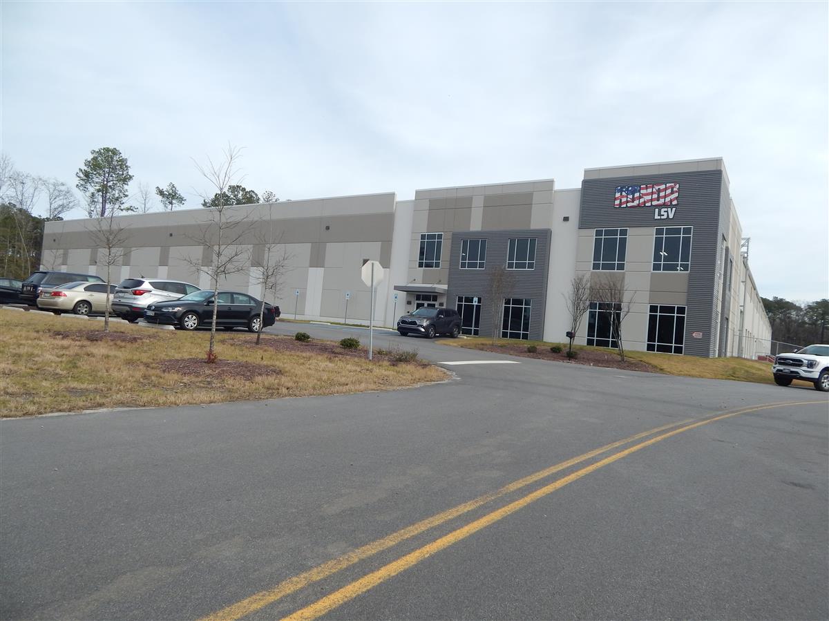
| Building Count: 1 Residence Count: 0 | Yard Item Count: 0 Mobile Homes on Property: 0 |
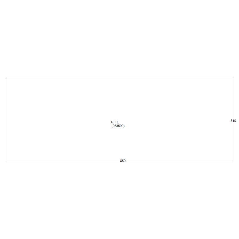
| Sub Area | Sub Area Description | Sketched Area (SqFt) |
|---|---|---|
| AFFL | 1st Floor | 263500.0 |
| Building Total Finished SQFT: 263500.0 | ||