| TMS: 207-00-02-059 Owner Information:
Owner Occupied Property: No Homestead Exempt (Age 65+ or Disability): No | Council District: C7 Fire District: F20 Tax District: T08 TIS Zone: 1 Jurisdiction: 6F Acres: 22.96 Lots: 0.0 |
Neighborhood: D137 - INDUSTRIAL NEXTON - JEDBURG Appraiser ID: GS Lot: TR A Block: Section: Zoning: Berkeley County - PD-OP/IP Parent TMS: Notes:SEP 5.128 (PARC A-1) PER CAB N PG 123-H 09/07 DELETED WAREHOUSE AND OFFICE REMOVED AND ADDED GAR FOR 2008 APPEAL BO 2/08 MCP ORD 07-12-84 EASTWAY PROPERTIES (2007) 4/2008 SOLD 97.06 (TR A-1) TO TC-MET OMNI PH 1 LLC 8/08 $2,950,000 IS THE CONSIDERATION FOR 207-00-02-059 & -129 (9242/100) 12/11 COMB 207-00-02-129 (PARC A-1 / 5.095AC) WITH THIS PARCEL PER PLAT CABP/25-P 12/11 SEP 1.384 AC & COMB WITH -109 PER DEED 10062 / 133 REC 4/13 & PLAT CABP/25-P REC 12/11 04/13 SEP 2.09 AC FROM 207-00-02-059 (NOW TR A, 218.47 AC) AND COMB WITH OMNI IND BLVD PH 2 R/W PER PLAT CAB S-241I SEP 207-00-02-144 (TRACT A-3, 25.81 AC) FROM 207-00-02-059 (NOW TRACT A, 192.66 AC) PER PLAT CAB S-244I COMB TRACT A-1, 50.53 AC (207-00-02-130) WITH 207-00-02-059 THEN SEP LOT 1, 100.41 AC (207-00-02-146), POA PARCEL #1, 13.70 AC (207-00-02-147) AND LOT 10, 35.01 AC (207-00-02-148) FROM 207-00-02-059 (NOW TRACT A, 94.10 AC) PER PLAT REC CAB S-88Q AND ADJ ACREAGE. SEP TRACT A-5, 71.07 AC (207-00-02-149) FROM 207-00-02-059 (NOW TRACT A RESIDUAL, 22.96 AC) OMNI IND COMMERCE PARK, PER PLAT REC CAB S-143Q/144Q |
| Site addresses: | |||||||||||||||||||||||||||||||||||||||||||||||||||||||||||||||||||||||||||||||||||||||||||||||||||||||||||||||||||||||||||||||||||||||||||||||||||||||||||||||||||||||||||||||||||||||||||||||||||||||||||||||||||||||||
|---|---|---|---|---|---|---|---|---|---|---|---|---|---|---|---|---|---|---|---|---|---|---|---|---|---|---|---|---|---|---|---|---|---|---|---|---|---|---|---|---|---|---|---|---|---|---|---|---|---|---|---|---|---|---|---|---|---|---|---|---|---|---|---|---|---|---|---|---|---|---|---|---|---|---|---|---|---|---|---|---|---|---|---|---|---|---|---|---|---|---|---|---|---|---|---|---|---|---|---|---|---|---|---|---|---|---|---|---|---|---|---|---|---|---|---|---|---|---|---|---|---|---|---|---|---|---|---|---|---|---|---|---|---|---|---|---|---|---|---|---|---|---|---|---|---|---|---|---|---|---|---|---|---|---|---|---|---|---|---|---|---|---|---|---|---|---|---|---|---|---|---|---|---|---|---|---|---|---|---|---|---|---|---|---|---|---|---|---|---|---|---|---|---|---|---|---|---|---|---|---|---|---|---|---|---|---|---|---|---|---|---|---|---|---|---|---|---|
| 636 OMNI INDUSTRIAL BLVD SUMMERVILLE, SC 29486, Unit/Lot: | |||||||||||||||||||||||||||||||||||||||||||||||||||||||||||||||||||||||||||||||||||||||||||||||||||||||||||||||||||||||||||||||||||||||||||||||||||||||||||||||||||||||||||||||||||||||||||||||||||||||||||||||||||||||||
| Owner: MWV OMNI LLC | Sale Date: 08/30/2018 | Sale Price: $900,000.00 | Deed Book-Page: 2837 - 366 | Plat: CAB S - 143Q | Transfer Notes: | Search Deed RecordsSearch Plat Records |
| Owner: EASTWAY PROPERTIES LLC , | Sale Date: 12/19/2011 | Sale Price: $0.00 | Deed Book-Page: 9242 - 100 | Plat: CAB P - 25P | Transfer Notes: PLAT RECORDED - CABP/25-P (220.557) 12/11 | Search Deed RecordsSearch Plat Records |
| Owner: EASTWAY PROPERTIES LLC , | Sale Date: 12/19/2011 | Sale Price: $0.00 | Deed Book-Page: 9242 - 100 | Plat: CAB P - 25P | Transfer Notes: PLAT CAB S-143Q/144Q (TRACT A, 22.96 AC) 4/17 | Search Deed RecordsSearch Plat Records |
| Owner: BAUCOM IMOGENE R | Sale Date: 02/19/1997 | Sale Price: $506,000.00 | Deed Book-Page: 1022 - 0252 | Plat: CAB L - 390 | Transfer Notes: 323.32 Acres Recorded on Plat CAB L - 390 | Search Deed RecordsSearch Plat Records |
| Owner: WESTVACO CORPORATION | Sale Date: 08/19/1996 | Sale Price: $3,500.00 | Deed Book-Page: 0932 - 0025 | Plat: CAB L - 390 | Transfer Notes: 9.54 Acres Recorded on Plat CAB L - 390 | Search Deed RecordsSearch Plat Records |
| Owner: CITIZENS & SOUTHERN NA | Sale Date: 06/25/1996 | Sale Price: $484,977.00 | Deed Book-Page: 0883 - 0060 | Plat: CAB L - 390 | Transfer Notes: 313.78 Acres Recorded on Plat CAB L - 390 | Search Deed RecordsSearch Plat Records |
| Owner: HIGH POINT CHAS BERK I | Sale Date: 11/02/1983 | Sale Price: $10.00 | Deed Book-Page: A533 - 0267 | Plat: | Transfer Notes: | Search Deed Records |
| Owner: HIGH POINT CHAS BERKEL | Sale Date: 11/09/1982 | Sale Price: $500.00 | Deed Book-Page: A487 - 0267 | Plat: | Transfer Notes: | Search Deed Records |
| Owner: WESTVACO | Sale Date: 07/26/1974 | Sale Price: $17,182.00 | Deed Book-Page: A275 - 0128 | Plat: | Transfer Notes: | Search Deed Records |
| Owner: T JACK BLACK ETAL | Sale Date: 07/25/1974 | Sale Price: $10.00 | Deed Book-Page: A275 - 0125 | Plat: FILE - | Transfer Notes: 264.19 Acres Recorded on Plat FILE - | Search Deed RecordsSearch Plat Records |
| Tax Year | Receipt # | Tax District | Original Total | Total With Penalties (if applicable) | Pay Date | Pay Type | Delinquent | Taxed Value | Owner Occupied (4% QR Rate) |
|---|---|---|---|---|---|---|---|---|---|
| 2023 | 0099417 | 8 | $321.00 | $321.00 | 12/28/2023 | Paid | No | $0 | No |
| 2022 | 0089545 | 8 | $25.00 | $25.00 | 01/10/2023 | Paid | No | $0 | No |
| 2021 | 0086092 | 8 | $25.00 | $25.00 | 12/31/2021 | Paid | No | $0 | No |
| 2020 | 0089042 | 8 | $25.00 | $25.00 | 01/12/2021 | Paid | No | $0 | No |
| 2019 | 0087008 | 8 | $25.00 | $25.00 | 12/23/2019 | Paid | No | $0 | No |
| 2018 | 0072944 | 8 | $25.00 | $25.00 | 01/15/2019 | Paid | No | $0 | No |
| 2017 | 0071382 | 8 | $50.00 | $50.00 | 01/10/2018 | Paid | No | $0 | No |
| 2016 | 0201735 | 8 | $50.00 | $50.00 | 01/13/2017 | Paid | No | $0 | No |
| 2015 | 0203114 | 8 | $2,857.88 | $2,857.88 | 01/15/2016 | Paid | No | $176,900 | No |
| 2014 | 0067956 | 8 | $88,918.84 | $88,918.84 | 12/29/2014 | Paid | No | $176,900 | No |
| Last Sale Date: 08/30/2018 Recording Date: 09/04/2018 Sale Price: $900000.00 | Plat Information: CAB S - 143Q Deed Book: 2837 Deed Page: 366 | Sales Validity: 0A Validity Other: Current Deed Record Current Plat Record |
| Building Market: 0 Land Market: 913,200 | Building Taxable (4% Res): 0 Building Taxable (6% Other): 0 Building Taxable (4% Ag): 0 Building Taxable (6% Ag): 0 | Land Taxable (4% Res): 0 Land Taxable (6% Other): 913,200 Land Taxable (4% Ag): 0 Land Taxable (6% Ag): 0 |
| Total Taxable Value: 913,200 Total Assessment: 54,790 | ||
| Fee Name | Fee Amount |
|---|---|
| Comm Fire Fee | 5,639 |
| Comm Land Fill Fee | 296 |
| Building Count: 1 Residence Count: 0 | Yard Item Count: 0 Mobile Homes on Property: 0 |
| Sub Area | Sub Area Description | Sketched Area (SqFt) |
|---|---|---|
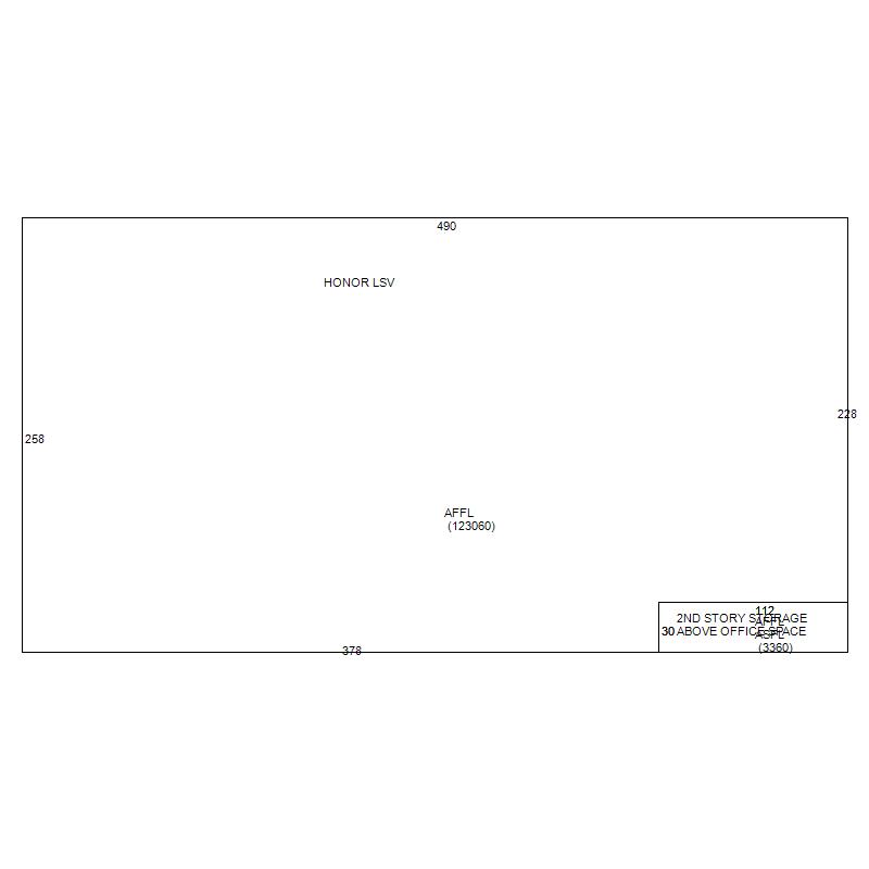
| AFFL | 1st Floor | 123060.0 |
| ASFL | Second Floor | 3360.0 |
| AFFL | 1st Floor | 3360.0 |
| Building Total Finished SQFT: 129780.0 | ||